More information
Qinghai Province
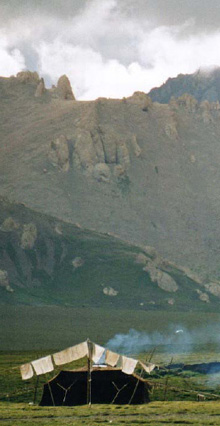
Qinghai Province is the fourth largest province in China, with a land area around 720,000 sq. km. It encompasses snow-capped mountains, arid deserts, vast grasslands and numerous wetlands. With fewer than 6 million people, the province still exhibits great cultural diversity. Crop farming is practiced in the northeast, but across most of the extraordinary landscape it is animal husbandry (pastoralism) which is most widely practiced.
Most of the province is a part of the greater Tibetan Plateau ecoregion. The Plateau is increasingly recognized in China and around the world for its global socio-ecological significance:
- It comprises the headwaters (or source areas) of several major Asian rivers, including the Yellow, Yangtze, Mekong, Salween and Yarlung Tsangpo (Brahmaputra) rivers, and thus contributes significantly to the livelihood and well‐being of nearly 40 percent of the world’s population;
- It is disproportionately affected by global climate change, with many glaciers melting rapidly, affecting local people as well as exporting regional impacts downstream;
- It provides habitat for many international endangered species including the Tibetan antelope, wild yak, argali, snow leopard, black necked crane, saker falcon and many other wild animals; and
- The plateau also supports a traditional way of life, Tibetan pastoralism, which has developed over centuries.
Biodiversity conservation and socio-economic development initiatives in Qinghai Province are increasing in number and prominence. The development of sustainable, reponsible tourism -- especially community ecotourism -- can be a part of the solution.
For more information about the province or the Tibetan Plateau region, please see the TibetanPlateau.org website or follow the links in the column to the left.
The Qinghai Tourism Bureau also is a good source of information, including its pictorial overview of special sites and regions in the province.